
How Pedestrian and Transit-Oriented Environments Attract Creative Jobs
While it is understood that pedestrian friendly and transit-oriented environments are elements of good planning, they are also starting to be understood as good business. The broader municipal decision-making community is realizing the important connection between transit, walkability and economic development.
The US-based Progressive Policy Institute’s comprehensive study of American urban centres, called the Metropolitan New Economy Index, looks at factors that attract knowledge workers in new economy sectors. The Index looks beyond typical quality of life factors, such as “high culture,” to include elements like walkability, or how well workers and residents can navigate the urban environment, congregate and network, on foot or by transit without the need for a vehicle.
This understanding hasn’t always been the case, as these elements were long seen as secondary to vehicular access in creating fertile economic environments. However, with a more contemporary view of urban economies gaining traction, a central question is: what is the impact of a walkable and transit accessible environment on jobs and economic development? Just as certain economic sectors require robust road and rail links to make locations attractive for business, what is the relationship between a hive of economic activity and the level of walkability and transit access?
Civicplan explored this issue with a particular focus on creative industries in the city of Hamilton, Canada. A mid-sized city, Hamilton is undergoing an economic transition from heavy industry to a substantially more diverse job base. Why focus on creative industries? From previous research we have conducted, we know there is a high concentration of creative industries in the downtown core. We also know about the significant growth in creative industry jobs downtown over the past few years. Finally, we know that the core is one of the more walkable environments in the local urban structure. From this basis, a number of questions can be posed:
- What is the measured level of walkability in the downtown?
- Where else in the city can we see these levels of walkability?
- What is the geography of transit access in Hamilton?
- Is there a spatial relationship between walkability, transit accessibility and creative industry jobs city-wide?
Measuring Walkability and Transit Accessibility
To measure walkability, the online tool Walk Score was utilized. Walk Score uses a variety of data sources to award location points based on the distance to amenities (grocery stores, restaurants, shops, banks, parks, school). The Walk Score was measured in the centre of all of Hamilton’s neighbourhoods and the results were mapped. Most of the highly walkable neighbourhoods are located in the lower city between the Niagara Escarpment and Hamilton Harbour and encompass downtown Dundas, through Westdale and Downtown, to Strathearne Avenue in the east.
In addition, a Transit Score was measured for each of Hamilton’s neighbourhood planning units using a similar methodology. Transit Score is a measure of how well a location is served by public transit based on data released by transit agencies. Five neighbourhoods ranked as having Excellent Transit surround the downtown. A number of neighbourhoods ranked as having Good Transit. These neighbourhoods spanned much of the lower city, from Westdale past the Red Hill Valley to Green Road in the east as well as extending onto the escarpment to include 13 neighbourhoods north of the Lincoln Alexander Parkway.
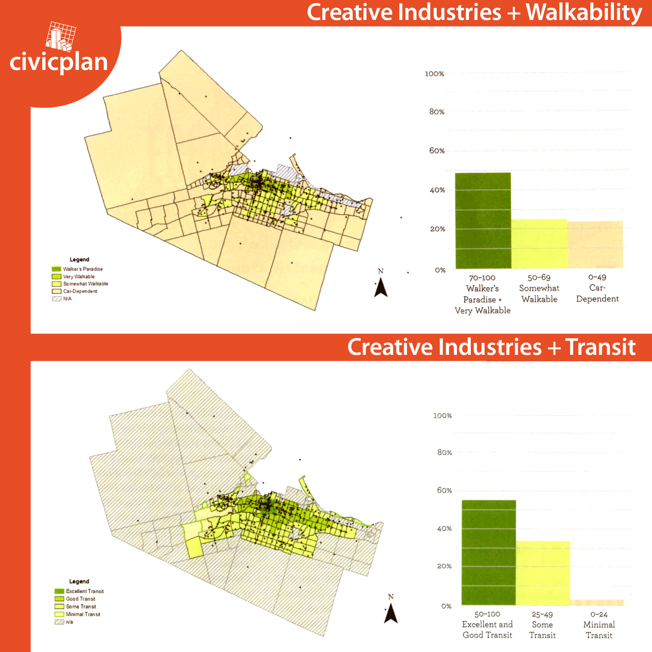
Creative Industries and Walkability
Creative Industries can be found throughout Hamilton but they tend to cluster in certain areas. When you overlay creative industries with the Walk Score map, the analysis shows that almost half of the businesses are located in neighbourhoods ranked in the top two categories of walkability. Particular clusters of note include the neighbourhoods in and around downtown Hamilton (Central, Beasley, Durand, Corktown) and south-west (Strathcona, Kirkendall) as well as downtown Dundas.
Creative Industries and Transit
When you overlay creative industries with the Transit Score map, the analysis shows that over half of the businesses are located in neighbourhoods ranked in the top two categories of transit access. In the top category alone, the neighbourhoods of Central, Beasley, Corktown, and Durand have a significant cluster (25%) of all creative industries. Further, about 40% of all creative industries are within a 500 metre zone along King Street from Highway 403 to the Red Hill Valley Expressway. This zone overlaps a significant portion of the planned Light Rail Transit route.
Observations
The analysis reveals a number of interesting trends. There is a clear spatial relationship between creative industries and neighbourhoods in Hamilton that rank higher in walk and transit scores with a distinct clustering of businesses in areas close to or within the neighbourhoods that rank highest on both scores. Further, we know from recent job survey data that creative industries are a fast growing sector in Hamilton and this shows that walkable and transit accessible environments are areas of job growth.
So why does this link exist? Research by urban researchers and other professionals is starting to shed light on this question. First, walkable places benefit from being near other walkable places, creating natural clustered districts on the urban landscape that can help create a critical mass of economic activity, as has been observed with creative clusters in Hamilton (e.g. James Street North, Locke Street South, Downtown Dundas). Second, residents of more walkable places have lower transportation costs and higher transit access. In Hamilton, the areas with higher walk and transit scores have many more options for mobility, creating economic flexibility in transportation. In addition, the different clusters of creative industries are well connected to one another with public transit, because they are located along major east-west and north-south transit corridors.
Conclusions
Moving forward, these factors can help inform local efforts at job creation. More specifically, walkable environments should be viewed as economic infrastructure that attract employment and should be invested in accordingly. This means that just as investments are made to ensure suburban business parks have the required infrastructure to make them centres of private investment, walkable environments needs to be created, enhanced, and maintained in order to attract jobs for other sectors. Practically speaking, this points to a whole host of planning issues ranging from pedestrian-friendly urban design to intensification. The same could be said for transit-accessible environments and this links directly to the east-west Light Rail Transit project in the lower city.
Strengthening the link between walkability, transit accessibility and jobs will be important for urban centres like Hamilton to effectively build strong, diverse economies moving forward. With limited resources to spend on economic development, decision makers need to ensure they are investing in parts of their cities that will provide a sustained return on investment, and create jobs that will attract and retain mobile talent. In Hamilton, the growth of creative industries, the talent they attract, and the geographic clustering they exhibit, point to the types of locations that achieve this goal.
This post was adapted from an article that was previously published in Plan Canada.